
2021 - ongoing
Burgh-Haamstede
2021 - ongoing
Burgh-Haamstede
For the villages of Haamstede, Burgh, and Westenschouwen – located along the inner dune edge of Schouwen-Duiveland – Bureau B+B developed an integrated development plan. This plan, titled Park Burgh-Haamstede, was created in close collaboration with the local business association and village council.
Location
Burgh-Haamstede
Client
Gemeente Schouwen-Duiveland
Year
2024 - 2025 (Execution Ring Haamstede)
Collaboration
Juust mobiliteit
Surface Area
Dorpsas: 4.5 km
Kern Haamstede: 1.5 ha
With Park Burgh-Haamstede, the village ribbon is taking steps toward improving the vibrancy, livability, and overall appearance of the villages – goals outlined by the Municipality of Schouwen-Duiveland in its Burgh-Haamstede Village Vision (KuiperCompagnons 2020). The plan builds on the distinctive qualities of Burgh-Haamstede. The municipality now stands on the threshold of several major projects moving forward towards implementation. The redesign of the village axis and the center of Haamstede marks the first step in realizing the Park Burgh-Haamstede vision.

The villages of Burgh, Haamstede, and Westenschouwen are uniquely situated in the green-blue oasis of the Zeeland delta. Their location within the future UNESCO Global Geopark Scheldt Delta – surrounded by landscapes of national importance such as the North Sea coast, the Oosterschelde National Park, Delta Park Neeltje Jans, and three Natura 2000 areas (Kop van Schouwen, Grevelingen, and Oosterschelde) – gives Burgh-Haamstede exceptional natural assets. At the same time, the villages face challenges such as high tourism pressure, a declining level of amenities, a shortage of housing for first-time buyers, and a sparse and outdated public realm that puts livability under strain.
Park Burgh-Haamstede aims to improve livability and spatial quality by reconnecting with the original identity of the villages along the inner dune edge. The name refers to the landscape qualities that make Burgh-Haamstede so special. Together, the villages and surrounding landscapes can be seen as a high-quality “landscape park” where living, daily life, leisure, and recreation go hand in hand.


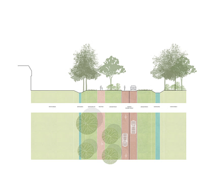
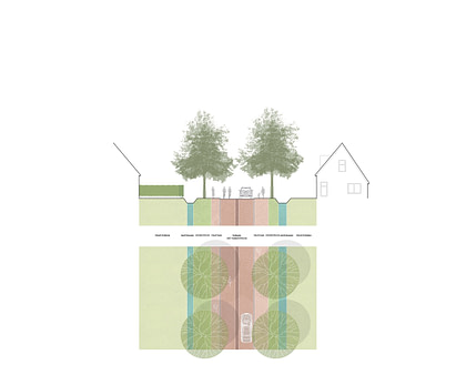
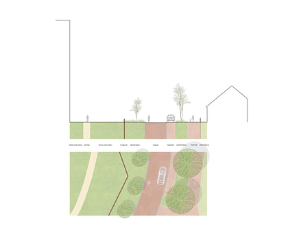
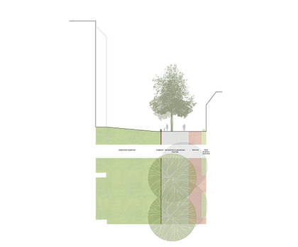
The landscape framework of tree-lined paths, hedgerows, and meadows allows Burgh-Haamstede to be read as a cohesive park: Park Burgh-Haamstede. At its foundation is the original structure of the inner dune edge. Positioned between the dunes and the polder, the villages are connected by a central road – this village axis forms the backbone of the area, flanked on either side by a dune ribbon and a polder ribbon. Perpendicular to the axis, hedgerows (formerly alder groves) form a mosaic of ‘landscape rooms’. While many of these have been filled in with residential areas and holiday parks, the hedgerows still provide green links between dune and polder. In some places, the landscape rooms remain undeveloped, offering unique scenic value. The landscape park surrounding the Carolingian ring fortress in Burgh is the best example of this. The visual quality plan for Park Burgh-Haamstede offers guidelines for preserving these original landscape features and using them as the foundation for future development.
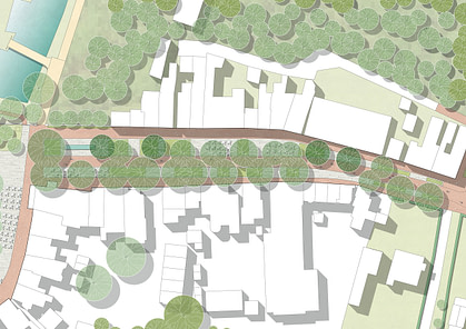
A key part of the transformation is the redesign of the village axis. This central road ties the villages together within the inner dune edge. Currently, it handles a large volume of through-traffic, but changes to the traffic structure will encourage vehicles to use the nearby regional road instead. Relocating the supermarket cluster to a more accessible location for cars will also reduce traffic pressure on the village axis.


Redesign of Haamstede
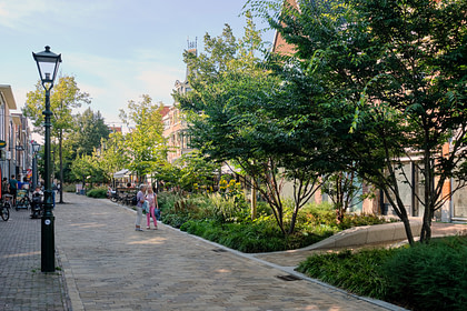
The redesign of Haamstede’s village center is a key project within Park Burgh-Haamstede. As the first village in the ribbon, it serves as the gateway to the village axis. By making the village center car-free during the busy summer season and introducing one-way traffic during the rest of the year, the traffic system will encourage most vehicles to use the regional road, making both the axis and village centers more pedestrian-friendly.
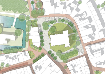
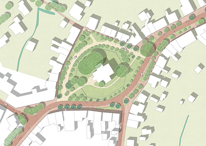
This created an opportunity to redesign the Ring and Noordstraat, the most important public spaces in Haamstede, showcasing the sublime qualities of a ring village located near the castle of Haamstede, surrounded by the woods and polders of the Kop van Schouwen.
The Ring is Haamstede’s central square. In its center stands the church, enclosed by a circular garden. A newly built, curved church wall defines the square and doubles as a long seating edge. Terraces from nearby cafés and restaurants line the square. It serves as a lively venue for events and activities, yet remains a peaceful and intimate space on quiet days. The adjacent castle square offers a beautiful view of the formerly hidden Castle of Haamstede.