
2014 - 2016
Stadspark Kerkrade
2014 - 2016
Stadspark Kerkrade
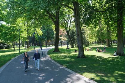
The City Park in Kerkrade was laid out at the beginning of the 20th century in a classical English landscape style. There are winding pathways, water features, tree clumps and a deer park. A former landfill on the location creates a significant height difference. The City Park is a green hub between the town centre, the Gaia Zoo, Erenstein Castle and the surrounding countryside. Several additions and alterations have disorganized the park during the course of the years. Bureau B+B was commissioned to turn the site into an attractive unity.
Location
Kerkrade
Client
Gemeente Kerkrade
Year
2014 - 2016
Surface Area
7,5 ha

In the past, a brook used to run through the site of the City Park: the Nierspringbeek. The landfill forced this brook to become an underground stream. Today, the water flows visibly through the park again. In the highest part of the park, the water springs in a ‘well’, an attractive fountain in a flowing basin with stepping stones. The water flows from the ‘well’ into a cobblestone gutter through the park, downhill over the several terraces. The deeper the brook flows into the park, the more natural the watercourse becomes. The brook ends in a pond at the lowest part of the park. The brook serves as a connecting feature and a playful object. At the same time, it regulates the drainage of rainwater from the surrounding neighbourhoods. During heavy downpours, the brook turns into a fast flowing rapid.


Bureau B+B encountered a dissected park in Kerkrade. On one side the deer park blocked the spatial unity. On the other side, a steep ridge did the same. The deer park was relocated and the ridge was transformed from an obstacle into a place of interest. Natural stone edges create terraces like an amphitheatre. The dense vegetation is opened up for panoramic views. A new pathway structure creates physical connections. The entrances are marked more prominently, making the park a natural route between the town centre, the surrounding neighbourhoods and the countryside.


The soil of the former landfill is polluted. When the landfill was still in use, the garbage was covered with soil before the next layer was dumped. The ground is a mixture of 50% litter and 50% soil. This means that the site is not so dirty that it has to be cleaned up, but still too dirty to excavate. The only way to adjust the relief was to add soil. It was a challenge to create attractive slopes in this manner while saving as many trees as possible.


